
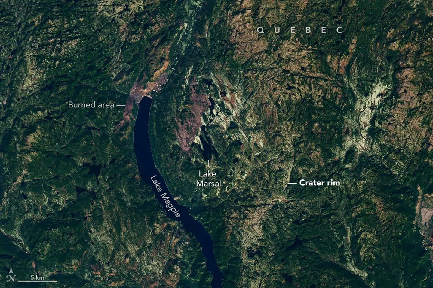
Joel Lapointe just wanted to find a good spot for a tent. He was scrolling through satellite maps of Quebec's Côte-Nord region, looking for bays and forest trails, when something caught his eye that looked like nothing else around it: an almost perfect circle wrapped around Lake Marsal, as wide as a small town. Lapointe isn't a geologist. He's an amateur astronomer. But his hunch turned out to be right — the site really does hold an asteroid impact crater, formed around 390 million years ago.
It's the kind of story that sounds too good to be true: an ordinary man with a laptop finds something that had sat right under scientists' noses for centuries. Yet that's exactly what happened, even though the path from "I spotted something odd" to "confirmed crater" took nearly two years and a lot more work than one click of a mouse.
From Google Maps to a seaplane in the taiga
Lapointe noticed the circular shape in 2024 and didn't keep it to himself. He reached out to scientists, and the find made its way to researchers at a Meteoritical Society meeting that same year. Word spread, and it turned into a real expedition. In October 2025, a team led by Gordon Osinski, a planetary geologist at Western University in Canada and director of the Earth Impact Database, flew to Lake Marsal — by seaplane, since there's no other way to reach that remote stretch of Côte-Nord.
The goal was simple: find something on the ground that can only be explained by a hit from a space rock. And they found it. On the expedition's second day, the team spotted so-called "shatter cones" — distinctive cone-shaped fractures in rock that form only under the huge pressure of a meteorite's shock wave. Scientists call them the only proof of impact you can spot with the naked eye, no lab needed. They also found pieces of impact melt rock, stone that briefly melted from the energy of the collision.
How big and how old is the crater
Lab tests on the samples narrowed the age of the impact to between 370 and 400 million years, with 390 million as the most likely figure — the Devonian period, long before dinosaurs walked the Earth. The structure is huge: about 25km across, with a clear central rise and steep rock walls typical of what scientists call complex craters. That makes it the biggest new crater find since 2018, when the roughly 31km-wide Hiawatha crater turned up under Greenland's ice.
Scientists have proposed a name for the find — Uhackatik — but they didn't pick it on their own. Before announcing it, they checked with the Innu Council of Ekuanitshit, whose traditional lands cover the area. It's not just a courtesy: it shows that modern impact science also means talking with the communities who have lived on that land for centuries.
Where the story is more complicated than it sounds
Headlines around the world cast it as "amateur finds crater alone," but the facts show something more modest — and more interesting. Lapointe pointed to the spot and raised the question, but turning that into a confirmed scientific fact took months of fieldwork, lab dating and expert sign-off. Shatter cones can't be seen from satellite; you only find them with a hammer and a magnifying glass on site. The crater still awaits official recognition from the Meteoritical Society's committee — for now its status is provisional, not final. It's also worth noting it isn't the first of its kind in the region: this brings confirmed impacts in Quebec to eleven, and in all of Canada to 31, out of only about 200 known craters worldwide. In other words, the find is rare but not unheard of — it just shows how much of the planet still hasn't been checked closely.
Osinski, who led the expedition, explained why the topic isn't just academic curiosity: an impact of this size today would wreck an entire region and cause climate effects felt worldwide. That's why every new crater helps scientists build a fuller picture of how often Earth has been hit through its history — and how rare that really is.
The takeaway for readers here
Beyond the geology, the story carries a simpler message. Lapointe put it plainly: he wants people not to brush off their own hunches or observations, even outside their field. Today anyone with an internet connection can look at nearly any corner of the planet through satellite images — the same tools people use to plan a holiday or check out a neighbour's yard turn out to be powerful enough to reveal traces of an event from almost 400 million years ago. Not every odd hole on a map is a crater, of course — most turn out to be ordinary lakes, quarries or quirks of geology. But every so often, out of a few hundred tries, something like Lake Marsal happens: a curious look at a map, followed by scientists willing to hop on a seaplane and check it out.
Source: thebrighterside.news


Коментари (0)
Все още няма коментари.